MORAGAHAKANDA–KALUGANGA PROJECT IS A CONTINUATION OF AND CONTRIBUTION TO SRI LANKA’S HYDRAULIC CIVILIZATION NURTURED BY A RICH IRRIGATION HERITAGE. AS SRI LANKANS, WE ARE COMMITTED TO KEEP THESE TRADITIONS ALIVE BY THE DEVELOPMENT AND MANAGEMENT OF THE WATER AND LAND RESOURCES FOR SUSTAINABLE USE. OUR POLICIES, PLANS AND PROGRAMmeS ARE GEARED TO ACHIEVE THESE ENDS. AS THE PRESIDENT HAS DECLARED RECENTLY, ‘MORAGAHAKANDA – KALUGANGA PROJECT WILL END THE SORROWFUL STORY OF RAJARATA FARMERS’ BUT, AT THE SAME TIME, WILL OPEN NEW VISTAS FOR DEVELOPMENT IN MANY SPHERES OF ECONOMIC AND SOCIAL LIFE OF SRI LANKA.
Enshrinement of Treasures (nidhan vastu) at the main dam of Kaluganga Reservoir marks an important land mark as it re-awakens memories of a rich heritage of construction of reservoirs and irrigation systems in the history of Sri Lanka.
 As is well-known, the early settlers of the dry zone felt the need to preserve water for agricultural purposes and the first reservoir, Abhaya Wewa (present Basawakkulama) was built during the reign of Pandukhabhaya in circa 300 B.C. With the increase of the population and expansion of the habitable domains, the need for development of the irrigation systems was felt more and several major reservoirs had been built by rulers and these reservoirs, coupled with the stupas ( dagabas), gave rise to a culture popularly known as the ‘culture of the tank and the dagaba’.
The purpose and determination in the construction of the irrigation systems are depicted by the words of Parakrama Bahu the Great,( 1153–1186 AD): ‘Let not even a drop of rain water go to the sea without benefiting man’. British governor, Sir Henry Ward, highlights the irrigational achievements of our ancestors when he states, ‘It is possible, that in no other part of the world are there to be found within the same space, the remains of so many works of irrigation, which are, at the same time, of such great antiquity, and of such vast magnitude as Ceylon. Probably no other country can exhibit works so numerous, and at the same time so ancient and extensive, within the same limited area, as this Island’.
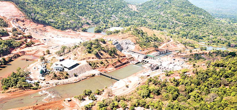
Kaluganga Reservoir, one of the twin reservoirs of the Kaluganga – Moragahakanda multi purpose development project is situated beneath the Knuckles Mountain Range that lies in Central Sri Lanka in the district of Matale.
The dam is located across the Amban Ganga about 30 miles above the river mouth and about ¾ mile upstream of the existing Elahera Anicut and about 10 miles below the Bowatenna reservoir.
The dam is approximately 20 miles away from Dambulla, the nearest town, and is situated near the tenth mile of the Naula-Pallegama road. The nearest railway station is Kekirawa.
The importance of this site for a massive irrigational system seems to have known as far back as the 2nd century for there is evidence that King Vasabha has constructed a reservoir here in 111 A.D. Five centuries later, king Aggabodhi II, (circa 600 A.D.) built Hatthotuwa Amuna (anicut) intercepting Kalu Ganga in order to enhance the water supply to Kantale reservoir. What now happens, therefore, is a revisit to a place where our forefathers utilized their knowledge and technology to bring water from the central highlands to the dry zone to make Sri Lanka, the ‘Granary of the East’.
Selection of the two sites, Moragahakanda and Kaluganga, distanced by approximately 10 Km. from each other to construct two reservoirs intercepting Amban Ganga, a major tributary of the Mahaweli which collects waters from the Northern slopes of the Knuckles Range was after a careful consideration of many salient features. The knuckles Range was the name given by the British surveyors to a mountain range that the locals have traditionally referred to as Dumbara Kanduvetiya, meaning mist-laden
mountain range. The area has a heavy rainfall and, in addition to its aesthetic value, the range is of great scientific interest. It is a climatic microcosm of the rest of Sri Lanka as it represents all the climatic zones in the country. Isolated cloud forests at higher elevations are harbouring a variety of flora and fauna, some of which cannot be found anywhere else in the world. It is also home to a significantly higher proportion of the country’s biodiversity. Despite its richness, the area, for centuries, was a neglected and isolated area awaiting attention of the powers that were.
 Providing water to the dry northern areas utilizing Mahaveli has been investigated soon after Independence and according to the Mahaweli Master Plan of 1958, the development of Mahaweli was to be implemented at three stages namely, (a) Polgolla Diversion during 1969-’73; (b) Victoria-Minipe Diversion during 1973-1977; and (c) Moragahakanda Multi-Purpose Reservoir during 1977-’80, to provide irrigation facilities to North and North-Central Provinces.
Of the three, Polgolla Diversion including Ukuwela and Bowatenna was completed during 1973-’77 while Victoria-Minipe diversion has been completed in six years under accelerated Mahaweli Scheme during the Presidency of J. R. Jayewardene but Moragahakanda was not considered under the AMS and, though discussed on a number of occasions, had to wait for a few decades due to several political as well as economic constraints.
After a lapse of a considerable period, the project recommenced in 2007 when the President was the Minister of Mahaweli Development, but very little progress has been made due mainly to the fact that the required monetary allocations have not been made. However, it is heartening to note that Morgahakanda/Kaluganga, the last project of the five great reservoirs in the Mahaweli Master Plan is currently being carried out under the direct supervision of President Maithripala Sirisena. Construction of two major reservoirs (Moragahakanda and Kaluganga) with a conveyance system consisting of two tunnels and transfer canals, and a power house of 25 MW installed capacity consist of the project configuration. Its Dam has a roller compacted concrete main dam and two rock fill saddle dams with a height of 65 meters and active storage of 521 million cubic meters or 465,000 acre feet.
Similarly Kaluganga Reservoir Dam has a rock fill main dam and two saddle dams, one rock fill and the other earth with a height of 67 meters and active storage of 144 million cubic meters or 210,000 Acre feet. Taken together, capacity of these two reservoirs is six times greater than that of Parakrama Samudra (110,000 acre feet) and naturally, this is the second biggest project of the Mahaweli scheme after Victoria. Moragahakanda is funded by the China Development Bank while Kaluganga is funded by the Kuwait Fund for Arab Economic Development, Saudi Fund for Development and the OPEC Fund for International Development. The total project cost is estimated at Rs. 100 billion. Construction of reservoirs is being handled by Synohydro Corporation of China and plans have been made to fill the reservoir by November this year.
The objective of the overall project is to collect the water that is at the basin of the Amban ganga and to distribute it among the Matale, Anuradhapura, Polonnaruwa and Trincomalee districts, to be used for agricultural needs during the Yala and Maha seasons. The transfer of water from this project to Mahakanadarawa tank by a 94.5 km long canal (with a tunnel 23.5 km long) would also make it possible to feed about 1000 minor tanks in the dry zone, feeding Hurulu wewa, Era wewa, Tisa wewa, Nuwara wewa and Nachchaduwa wewa in the Anuradhapura District and Parakrama Samudra, Minneriya, Giritale. Kaudulla and Kantale tanks in the Polonnaruwa and Trincomalee Districts. The NCP canal sub projects, namely, Padawiya, Wahalkada and Pavattakulam schemes will provide relief to plight of farmers in remote villages of Kebithigollawa, Horowpathana, Medawachchiya, Kahatagasdigiliya, Rambewa and Mihintale.
The benefits of this project are enormous and spread into diverse areas. In the agricultural sector, the project would, most importantly, provide domestic and industrial water to improve irrigation facilities to existing water scarce 82,000 hectares of farm lands and open up 5000 hectares of new land for the development of agriculture in the North Central, North, North East and North Western Provinces and this would facilitate an increased rice yield per hectare with an additional agriculture production of 109,000 tons annually.
From paddy cultivation alone, there would be a benefit worth around US$ 30 million while the reservoirs that would create a source of inland fishing and the fresh water fish breeding industry, would contribute approximately US$ 1.67 million to the national economy. By providing drinking water, It would also relieve many thousands of people some of whom are suffering from kidney diseases due to non availability of drinking water.
Transportation network in the area is improved. Koombiyangahaela to Moragahakanda relocation of 13.5 km have been completed while the 24.1 km new road from Moragahakanda to Thorapitiya, Wellewela via guruwela new settlement area too has been constructed. Existing road network and new market roads too have been improved and new hamlets have grown up in and around these areas. Development of Guruwela and New Laggala towns are in progress while construction works of post offices, health care centers, administrative buildings and schools have been completed. Although construction of Guruwela police staff quarters have been completed, construction of the police station is in progress. Families affected by these developments have been resettled in Guruwela and Thorapitiya.
Sri Lanka’s present commitment to develop ‘A Blue Green Era’ as per the vision of H.E. the President is being put into actual practice in the development strategies of the Moragahakanda – Kaluganga project. Reforestation of approximately 1375 ha in the immediate catchment of Amban Ganga basin, creating a buffer zone around Moragahakanda Reservoir and reforestation of 650 ha inside this buffer zone, rehabilitation of tanks in adjacent nature reserves and eradication of invasive plants, introduction of new farming technology with organic farming, concentrating more on sustainable development, alleviating the disasters caused annually by floods in Manampitiya-Somawathiya area and construction of ‘smart green villages’ are things noteworthy in this regard. Similarly establishment of an elephant corridor between Giritale – Minneriya nature reserve, development of Wasgamuwa National Park and habitat enrichment in those areas are meant to safe guard and enrich wild life.
The project and the associated road network expanding to Anuradhapura,Polonnaruwa, Matale, Trincomalee and Vanni district will facilitate transport, develop human relations while encouraging the development of tourism industry in diverse manners. Minneriya, Wasgamuwa, Maduru Oya, and Somawathiya are wild life attractions while Riverston and Knuckles would attract nature lovers and, for those interested in Archaeological and historical sites, Sigiriya, Dambulla, Anuradhapura, Polonnaruwaa and Trincomalee would offer many golden opportunities.
New avenues for Agro Tourism and Eco Tourism will open with the development of ‘smart green villages’ and this would provide a new source of income for the farming community in the area. Since the area is rich in other natural resources such as gems and minerals these remain to be explored for better economic prospects.
The writer is the Mahaweli Development and Environment Ministry Secretary.
Add new comment